Randy at Cache Creek, CO, with Mom & Sister -- 29 July 15
17 posts
• Page 2 of 2 • 1, 2
Re: Randy at Cache Creek, CO, with Mom & Sister -- 29 July 15
![]() by russau » Sun Aug 09, 2015 5:08 pm
by russau » Sun Aug 09, 2015 5:08 pm
Well CG don't you and your husband become a stranger!
- russau
- Posts: 5924
- Joined: Wed Jan 27, 2010 6:17 am
- Location: St. Louis Missouri
Re: Randy at Cache Creek, CO, with Mom & Sister -- 29 July 15
![]() by C-17A » Sun Aug 09, 2015 6:41 pm
by C-17A » Sun Aug 09, 2015 6:41 pm
Contrygal,
Well..............it's REAL easy to find...
When you turn off of Hwy 24 at Granite..............on County Road 398........a good dirt road..........going West, behind the old Granite Store..............now converted into Sage Outdoor Outfitters.....cross over the cattle guard in about 1/4 mile and then you're on the BLM Cache Creek property.
Just keep going on CR 398 for about another 3/4 miles and you'll see CR 398D on your left, heading South. Take it the 1/4 mile to the Granite Cemetery.
Park there, then walk around the cemetery South, down the hill to Cache Creek below. Maybe a couple hundred yards. I dig up in the old dry gulch that head up (South) from the creek and pan/sluice that material.
Easy going down. Takes me about 4 short rest stops coming back up with my equipment. Remember, you're at 9,200 feet elevation, so the air is thin. Go slow, drink lots of water, pace yourselves...
HTH,
Randy "C-17A"
- C-17A
- Posts: 182
- Joined: Fri Feb 12, 2010 6:24 pm
Re: Randy at Cache Creek, CO, with Mom & Sister -- 29 July 15
![]() by contrygal » Tue Aug 11, 2015 9:29 pm
by contrygal » Tue Aug 11, 2015 9:29 pm
Russ and Randy thank you for all of the help with this.
We greatly appreciate it. I know I bugged you a lot. Will be in that area after labor day, and hopefully we will
make a lot of memories, take a lot of photos and get a bit of gold.!!
If things turn out well, we will come back next year to get out of this miserable heat here in the central valley of Calif.
May bring a few friends along and bring some business to Buena Vista. " Happy Trails"
Sincerely Jo Ann & Don
- contrygal
- Posts: 10
- Joined: Wed Mar 25, 2015 8:33 am
Re: Randy at Cache Creek, CO, with Mom & Sister -- 29 July 15
![]() by contrygal » Sun Aug 16, 2015 9:01 am
by contrygal » Sun Aug 16, 2015 9:01 am
Hello Randy;
One more quick question......

My husband is concerned about the Cache creek area having claims, that we are not aware of.
Is it all claimed up or can we go in, pick an area and do a little sluicing.???
Will only be there for 2 or 3 days, but do not want to trespass on anyone..!!
Thank you, Jo Ann & Don
One more quick question......
My husband is concerned about the Cache creek area having claims, that we are not aware of.
Is it all claimed up or can we go in, pick an area and do a little sluicing.???
Will only be there for 2 or 3 days, but do not want to trespass on anyone..!!
Thank you, Jo Ann & Don
- contrygal
- Posts: 10
- Joined: Wed Mar 25, 2015 8:33 am
Re: Randy at Cache Creek, CO, with Mom & Sister -- 29 July 15
![]() by C-17A » Tue Aug 18, 2015 6:26 am
by C-17A » Tue Aug 18, 2015 6:26 am
Contrygal,
The place I recommend is working the dry gulch directly below (to the South) of the old Granite Cemetery.
The cemetery is on County Road 398D just off CR 398.
Park there at the cemetery, walk around the cemetery and down the hill to Cache Creek. Directly to the South you'll see a small dry ravine/gulch zig sagging up from the creek. Walk up it a couple zigs & zags, maybe about 40 yards or so and dig material from the decomposing granite bedrock to about a foot up. Should look like a little orangish, compacted clay & gravels. Will need a pick to dig it. Pan & sluice that material.
Remember, you're at about 9,200 feet elevation, so the air is thin on oxygen. Walking down the hill is easy. I take 4 or 5 little rest breaks walking back up the hill to the parking lot. I recommend folks take 1 aspirin every morning, drink lots of water and take it easy to avoid altitude sickness from overexertion/dehydration. Especially if you're a lowlander.
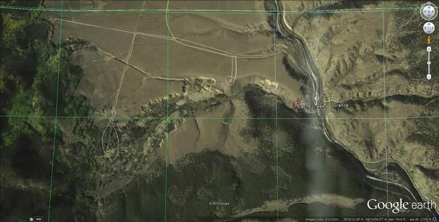
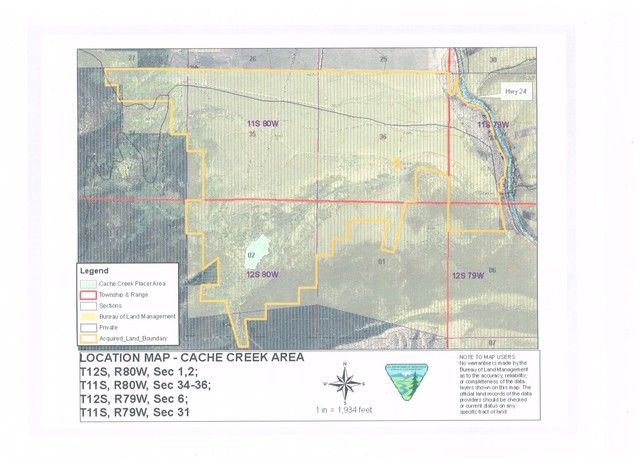
The 2,160 acre Cache Creek property is all open land.............not open to claiming...........so no worries on others' claims there. Avoid the 1 active claim well below down stream from the cemetery, on the right hand side of the creek, that's the South side. IF you get that far down, a good 1/4 mile or so, you'll see the monuments & claim signs. Also, the BLM Elephant Rock campground area on CR 371 a couple miles North of Buena Vista is open for panning & sluicing on the Arkansas River. You can prospect about 100 yards downriver and 1/4 mile up river.
Here's 2 maps of Cache Creek that might help. The cemetery is the first circled loop in the middle of the Google Earth view and the up creek "placering area" parking lot is the second circled loop:
HTH,
Randy "C-17A"
The place I recommend is working the dry gulch directly below (to the South) of the old Granite Cemetery.
The cemetery is on County Road 398D just off CR 398.
Park there at the cemetery, walk around the cemetery and down the hill to Cache Creek. Directly to the South you'll see a small dry ravine/gulch zig sagging up from the creek. Walk up it a couple zigs & zags, maybe about 40 yards or so and dig material from the decomposing granite bedrock to about a foot up. Should look like a little orangish, compacted clay & gravels. Will need a pick to dig it. Pan & sluice that material.
Remember, you're at about 9,200 feet elevation, so the air is thin on oxygen. Walking down the hill is easy. I take 4 or 5 little rest breaks walking back up the hill to the parking lot. I recommend folks take 1 aspirin every morning, drink lots of water and take it easy to avoid altitude sickness from overexertion/dehydration. Especially if you're a lowlander.
The 2,160 acre Cache Creek property is all open land.............not open to claiming...........so no worries on others' claims there. Avoid the 1 active claim well below down stream from the cemetery, on the right hand side of the creek, that's the South side. IF you get that far down, a good 1/4 mile or so, you'll see the monuments & claim signs. Also, the BLM Elephant Rock campground area on CR 371 a couple miles North of Buena Vista is open for panning & sluicing on the Arkansas River. You can prospect about 100 yards downriver and 1/4 mile up river.
Here's 2 maps of Cache Creek that might help. The cemetery is the first circled loop in the middle of the Google Earth view and the up creek "placering area" parking lot is the second circled loop:


HTH,
Randy "C-17A"
- C-17A
- Posts: 182
- Joined: Fri Feb 12, 2010 6:24 pm
Re: Randy at Cache Creek, CO, with Mom & Sister -- 29 July 15
![]() by contrygal » Tue Aug 18, 2015 6:29 pm
by contrygal » Tue Aug 18, 2015 6:29 pm
Thanks again Randy you are a blessing to us retired prospectors, 
You are a true professional !!!!!
Hope you are repaid in the " Yeller",
Happy trails, Jo Ann & Don
You are a true professional !!!!!
Hope you are repaid in the " Yeller",
Happy trails, Jo Ann & Don
- contrygal
- Posts: 10
- Joined: Wed Mar 25, 2015 8:33 am
Re: Randy at Cache Creek, CO, with Mom & Sister -- 29 July 15
![]() by russau » Sun Sep 13, 2015 4:01 am
by russau » Sun Sep 13, 2015 4:01 am
Well Countrygal , how did you two do on your trip? no pictures for the "show-n-tell"???
- russau
- Posts: 5924
- Joined: Wed Jan 27, 2010 6:17 am
- Location: St. Louis Missouri
17 posts
• Page 2 of 2 • 1, 2
Return to Rocky Mountain Prospecting
Who is online
Users browsing this forum: No registered users and 1 guest